Four Decades of Musing on Why the Earth Sometimes Quakes in New York City

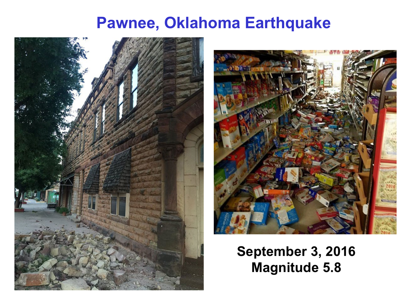
“…Thus, the cause of the earthquakes in this region remains an enigma.

Alan Kafka, Weston Observatory, Department of Earth & Environmental Sciences, Boston College

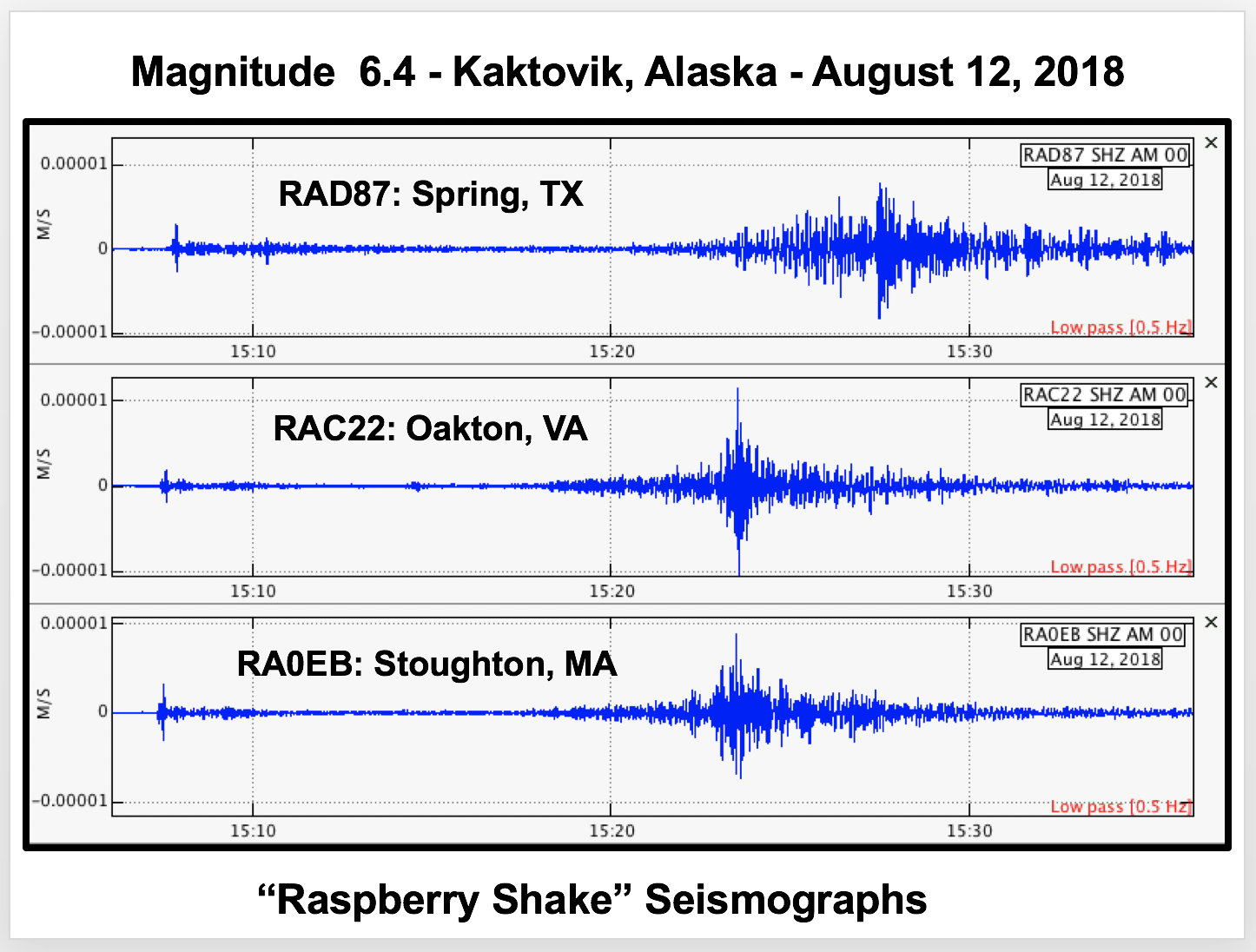
When people think of earthquakes, they probably think of a lot of places other than New York City, such as California and Japan. But (long ago), when I was in graduate school studying earthquakes in places like the Carribbean plate region, I discovered that earthquakes actually do occur all around my home town of New York City. Since then, I have been obsessed with the enigma of why earthquakes occur in the Eastern United States, and in the New York City area in particular, deep within the interior of the North American plate. 

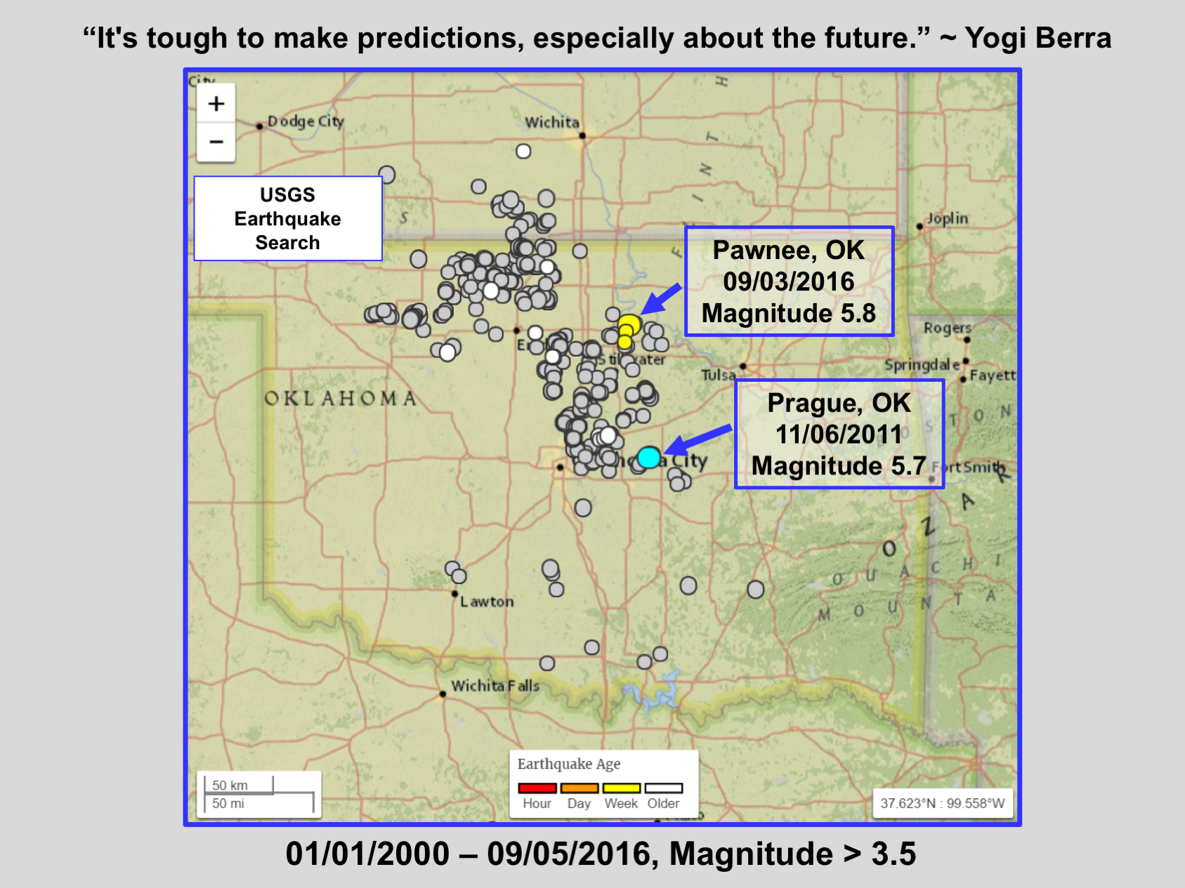
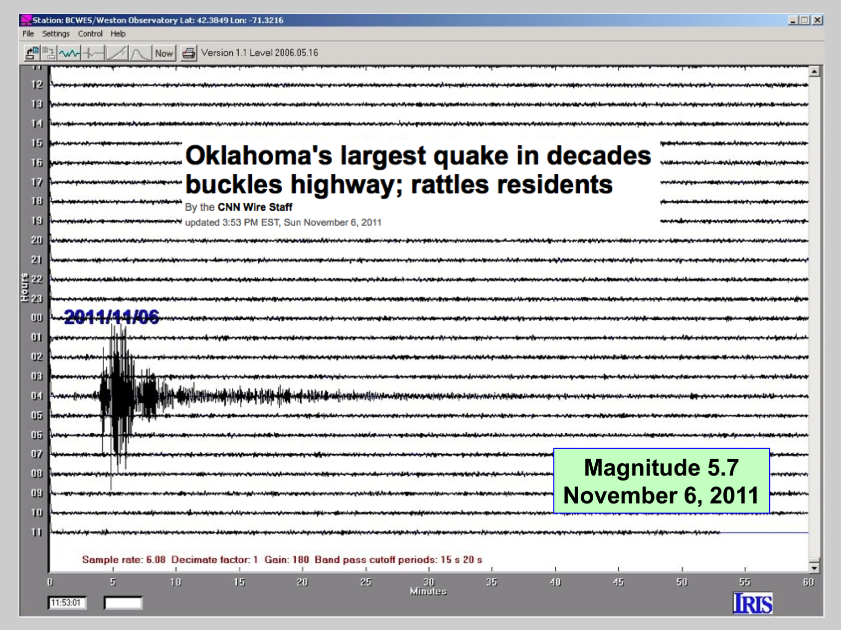
The area within a 100-km radius of New York City has had an intermediate level of seismic activity throughout its recorded history. It is, of course, not as seismically active as some parts of the Western United States, and it hasn’t experienced earthquakes as large as those in some other parts of the U.S. east of the Rocky Mountains, such as the 1811 to 1812 earthquakes near New Madrid, MO. Nonetheless, the New York City area has had its share of moderate-sized historic earthquakes. Unlike the situation in regions near plate boundaries, such as along the San Andreas fault zone, the pattern of the seismicity in the New York City area does not show any clear concentration of activity along geologically mapped faults (e.g., Kafka et. al., 1985, 1989). Thus, the cause of the earthquakes in this region remains an enigma.

I have been musing about this enigma for more than four decades. Here’s a sample of my musings:

Earthquake Activity in the Greater New York City Area: Magnitudes, Seismicity and Geologic Structures, A.L. Kafka, E.A. Schlesinger-Miller, and N.L. Barstow. Bulletin of the Seismological Society of America, 75(5), 1285-1300, 1985.

Earthquake Activity in the Greater New York City Area: A Faultfinder’s Guide, A.L. Kafka, M.A. Winslow, and N.L. Barstow, In Field Trip Guidebook, 61st Annual Meeting, N.Y. State Geological Association, D. Weiss, ed., 177-204, 1989.

Faults and Earthquakes in the Greater NY City Area: Reflections at the Intersection of Science, the Media, and the Public, A.L. Kafka (Blog, September, 2008).

Seismicity in the Area Surrounding Two Mesozoic Rift Basins in the Northeastern United States, A.L. Kafka and P.E. Miller, Seismological Research Letters, 67(3), 69-86, 1996.

“Cellular Seismology” of the Northeast Corridor of the United States, A.L. Kafka, Twitter.com/Weston_Quakes, September, 2020.

Public Misconceptions About Faults and Earthquakes in the Eastern United States: Is it Our Own Fault?, A.L. Kafka, Seismological Research Letters, 71(3), 311-312, 2000.

The Great Long Island City Earthquake of 2019 (Magnitude 0.9), A.L. Kafka, Twitter.com/Weston_Quakes, June, 2019.

Does Seismicity Delineate Zones Where Future Large Earthquakes Are Likely to Occur in Intraplate Environments?, A.L. Kafka, In Continental Intraplate Earthquakes: Science, Hazard, and Policy Issues, Geological Society of America Special Paper 425, Edited by S. Stein and S. Mazzotti, 35-48, 2007.

Why Does the Earth Quake in New England, A.L. Kafka (Blog, February, 2020).

A seismogram is an amazing thing…

Alan Kafka
Weston Observatory
Department of Earth and Environmental Sciences
Boston College

There are many excellent online videos and educational materials describing all aspects of seismology and seismograms, and for great examples, I highly recommend EarthScope Consortium.

But, just taking a moment to think about the bigger picture, and to get a more qualitative sense of what most seismograms you tend to see—and the ones I find most interesting—actually are:

We are living on a very active planet, and many earthquakes happen here every day. When a large earthquake occurs, it generates seismic waves that (unless the earthquake is very large, and/or you are very near the epicenter) are generally too small for people to feel. Even though we don’t feel them, these waves are often well recorded on seismographs at great distances (see examples below). As these seismic waves move through the Earth’s interior they are changed by variation in Earth structure along their path from the earthquake to the seismograph’s location. You can think of these waves as “silent waves” that are often happening right beneath your feet, but have motion that is so small it is not felt by people. The purpose of a seismograph is to magnify this motion, and plot it on a seismogram, so it can be “seen” by people (or maybe better, “heard” by seismographs).

And what is remarkable about these subtle, silent waves, is that when they are recorded on seismograms, the arrival times and shapes of the waves are systematic enough that seismologists can interpret them to determine a very complete story about such things as: where the earthquake occurred, how big it was, how deep it was, and how its fault moved. Furthermore, seismologists can also interpret the waves to determine the structure of the Earth in the region that the waves traveled through. 

That is a big part of the science of seismology, and that’s amazing!

Ridgecrest_OLBC
Seismogram of magnitude 7.1 earthquake that occurred in Southern California on July 6, 2019, recorded in Northeastern US. (EQ1 seismograph)
CostaRica_Seismogram
Seismogram of magnitude 7.6 earthquake that occurred in Costa Rica on September 5, 2012, recorded in Northeastern US. (EQ1 Seismograph)

Magnitude 6.0 earthquake in Honduras, recorded by Raspberry Shake seismographs in the Boston area.

Magnitude 7.7 earthquake in Jamaica, recorded at Weston Observatory and Blue Hill Observatory.


This magnitude 6.9 earthquake was not near population and was very deep, so it was not stronlgly felt (even near the epicenter). But, it shook the planet to the core…

How big of an “earthquake” was generated by the crowd at that football game?

Alan Kafka
Weston Observatory
Department of Earth and Environmental Sciences
Boston College

I have found that there’s something about a seismograph that invites people to jump up and down and then ask, “How big an earthquake did I just make?” As a seismologist, I also often get asked questions like, “What is the magnitude of a football stadium full of fans jumping to cheer for their teams?” Or, “What’s the biggest earthquake that could ever happen?”

Earthquakes are frightening, and people want to understand what they are all about. I think these questions are an expression of people trying to grasp the extent of the awesome power of nature that may result in tragic devastation and human suffering from earthquakes. Answering these kinds of questions can help people appreciate just how astoundingly huge earthquakes are, compared to just about anything else we typically experience.

So, how many people jumping 1 ft would generate the equivalent energy of, for example, a magnitude 5 earthquake? The surprising answer is: about 3.5 billion—or almost half the population of the Earth. And, what about a magnitude 6? That would be about 14 times the population of Earth!

This table shows the number of people jumping 1 ft that would be the equivalent energy for earthquakes of a given magnitude. (Yes, magnitudes can be negative.)

MagnitudeNumber of people jumping 1 ft
-14
0110
13,481
2110 thousandLarge football stadium
33.5 million
4110 million
53.5 billionAlmost half the population of Earth
6110 billion14 times population of Earth
73.5 trillion450 times population of Earth
8110 trillion14,000 times population of Earth
93.5 quadrillion446,000 times population of Earth

No matter how many times I go through these calculations, I still find the results to be astounding and hard to believe. But earthquakes really are that big, which explains why they cause such devastation and human tragedy.

Hopefully though, through better understanding of the science of earthquakes, we can mitigate at least some of the tragedy caused by earthquakes by learning about where they are likely to occur, how big they are likely to be, and what effects they are likely to have on people. The more we learn about earthquakes, the better we will be able to prepare for them and improve our response to them when they happen.


Further reading:

T. Bravo, M. Hubenthal, and J. Taber, How Big of a Quake Can You Make?, IRIS Teachable Moment, www.iris.edu/hq/retm/event/6512

P. Bormann and D. Giacomo. The Moment Magnitude and the Energy Magnitude: Common Roots and Differences. Journal of Seismology, Springer Verlag, 2010, 15 (2), pp.411-427. 10.1007/s10950-010-9219-2.. .hal-00646919.

Energy of Earthquakes, www.volcanodiscovery.com/earthquakes/energy.html

Reflections on the Role of “Consensus” in Scientific Research

Alan Kafka
Weston Observatory
Department of Earth and Environmental Sciences
Boston College

In a review of a paper in which we are exploring the extent to which some (or most, or “all”) Xs are Y, a reviewer wrote:

“The consensus in the community [studying this topic] is that all [Xs] are [Y].”

It wasn’t a “nasty” comment, but it did seem to be saying that we already know the answer (with some implication of so what’s the point of our study), and I don’t think we do know the answer (which is why we did the research and submitted the paper…).

So, I’ve been thinking: What is the role of “consensus” in a scientific research paper? I came across this, which gives me a starting point:

“Many people think that a scientific consensus refers to a large group of scientists who all agree that something is true. In reality, a scientific consensus is a large body of scientific studies that all agree with and support each other. The agreement among the scientists themselves is simply a by-product of the consistent evidence.” (www.facebook.com/thelogicofscience)

Is that it? Does science really work like that? But, doesn’t that leave a lot of “wiggle room”? For example, previous to the plate tectonics revolution, the scientific consensus was that continents don’t drift.

I’m not sure the scientific method is capable of “proving” that “all” of anything is ________. So it seems to me that the most we could accept would be that the consensus in the community [studying this topic] is that most [Xs] are [Y]. And, even if that is the case, then wouldn’t it be a very compelling question to explore what might be going on with the other Xs?

I think this overlaps with (but is not identical with) the question of how the public should relate to, and act upon, reports of scientific consensus in making public policy decisions. Scientific research can rarely (if ever?) “prove” something to be true. It can, however, in many cases provide a lot of guidance regarding how likely it is that something is true.

I think it should be left to each individual to decide the extent to which a reported scientific consensus should (or should not) be a compelling reason to believe it and/or act on it. But, making those kinds of informed decisions needs to be based on a firm understanding of how it all works within the world of scientific research.

Do I Think That Fracking Causes Earthquakes?

Alan Kafka
Weston Observatory
Department of Earth and Environmental Sciences
Boston College

(Last updated: February 4, 2024)

I often find myself in a situation where I am asked: “So, tell me, does fracking cause earthquakes?” Not wanting to get into a complex scientific and political argument on the spot (especially in social situations), I generally try to change the subject.

But, I guess there’s no avoiding it. Being a seismologist, I do have a responsibility to answer. So, here’s my take on it.

Short and simple answer: Yes.
Longer answer: But, it’s complicated…

“Hydraulic fracturing”, also known as “fracking”, is a method of injecting fluid into the ground to fracture rock for extracting natural gas and oil. Fracking provides new sources of natural gas that enhance our ability to generate electricity, heat homes, and provide fuel for transportation.

Since an earthquake is the release of energy due to fracture of rock inside the Earth, we would have to say that the process of fracking definitely creates many small earthquakes. These small earthquakes are generally too small to be felt and are not (so far?) the earthquakes that have been considered the biggest problem in terms of causing structural damage or injury. However, part of a fracking operation involves the use of high volumes of water to release natural gas from dense rock, and disposing of the associated wastewater involves injecting it into deep rock formations. That wastewater injection can “induce” or “trigger” earthquakes in faults that have been dormant (and might have otherwise remained dormant) for a very long time. These wastewater-injection induced earthquakes are not necessarily so small and can be damaging. And that is (so far?) where the fracking-earthquake problems and controversies lie.

Here’s my summary of what I think is (and isn’t) known about this story:

  • There are well-documented cases of earthquakes associated in time and space with fracking operations. But it’s not really the fracking itself that is the most likely source of damaging earthquakes. It’s the disposal of fluids via injection of highly pressurized wastewater into faults that more likely tends to induce the larger, potentially damaging earthquakes.
  • Most earthquakes associated with fracking operations have been smaller than about magnitude 3. But a few larger and damaging earthquakes are suspected of having been induced by the injection of wastewater from natural gas (and also oil production) operations. The figures shown below illustrate examples of some large and damaging earthquakes that occurred in Oklahoma and are suspected of having been induced by injection of wastewater associated with oil and gas industry extraction operations.
  • There is a well-known theoretical explanation of why injection of highly pressurized wastewater into faults could induce earthquakes. The increased pore pressure along the fault effectively lubricates the fault, causing it to release stress that might have been building up for many years, but might not have slipped without the excess pore pressure.
  • Not all fracking operations have been clearly identified as being related to induced earthquakes of any significant size. Since some fracking operations have not, it can be hard to discern if a given fracking operation necessarily presents a high level of earthquake hazard.
  • Just how large and damaging a fracking/wastewater injection-related induced earthquake could be remains unknown. Although such earthquakes are generally smaller than magnitude 3, and the largest claimed to be induced by injection of wastewater associated with oil and gas industry extraction are generally less than magnitude 6, larger future earthquakes cannot be ruled out. More research on this topic will be necessary to answer the question of just how big future wastewater injection-related induced earthquakes might ever be.
  • There are many other environmental issues related to fracking, such as heavy truck traffic and contamination of nearby well water used by local communities for drinking water. These types of environmental hazards are also important issues to consider regardless of the question of whether or not fracking operations induce earthquakes.

Bottom line for me: These kinds of things are complicated. I think a more relevant question than “Does fracking cause earthquakes?” is: Given that wastewater injection procedures associated with oil and gas industry extraction operations can induce earthquakes big enough to cause damage in some (small?) percentage of cases (and that there are other environmental hazards associated with fracking), what should we do about it?

Fracking does provide new sources of natural gas that enhance our ability to generate electricity, heat homes, and provide fuel for transportation. But, extracting natural gas with this method leads to some complex environmental problems. Given the uncertainties surrounding this issue, how do we find the right balance to make informed decisions about the extent to which the risks associated with fracking, or with any other process for finding new sources of energy, are worth the benefits?

This is the challenge for all of us as citizens of planet Earth.

Pawnee, OK quake
Magnitude 5.8 earthquake in Pawnee, OK (plus aftershocks).
Pawnee, OK quake damage
Damage from magnitude 5.8 earthquake in Pawnee, OK.
One week in OK.
Earthquakes recorded during just one week in Oklahoma.
Seismicity surrounding two large quakes in OK.
Seismicity in the region surrounding the 2011 (M5.7) and 2016 (M5.8) earthquakes in Oklahoma.
11/06/2011, OK quake
Weston Observatory/BC-ESP seismogram of magnitude 5.7 earthquake that occurred in Oklahoma on November 6, 2011. This earthquake is likely related to injection of highly pressurized wastewater (from oil and gas industry extraction operations) into wells. It was big enough to cause injuries and damage more than a dozen homes.

Further Reading:

Induced Earthquakes, U.S.Geological Survey.

Global Review of Human-Induced Earthquakes, G.R. Foulger, M.P. Wilson, J.G. Gluyas, B.R. Julian, and R.J. Davies. 2017. Global review of human-induced earthquakes, Earth-Science Reviews, 178: 438–514, 2018.

It’s Not Just Fracking: New Database of Human-Induced Quakes, J. Wendel, Eos, 97, December 22, 2016.

Oklahoma’s Largest Earthquake Linked to Oil and Gas Industry Actions 3 Years Earlier, Study Says, InsideClimate News, 2017.

New Findings on Earthquakes and Oil and Gas Extraction in the United States, The Conversation, 2017.

Earthquakes happen…

Alan Kafka
Weston Observatory
Department of Earth and Environmental Sciences
Boston College

On August 12, 2018, an unusually large earthquake (magnitude 6.4) occurred in northern Alaska, in an area that is being considered for oil and gas drilling. See our seismograms below, and this link:

Large Earthquake in the Arctic National Wildlife Refuge Raises Questions About New Oil Drilling Leases (temblor.net)

Why an earthquake this large happened, in this particular location, and at this particular time remains an enigma.

I think the most important take-home message here is not necessarily the specifics of the oil drilling/environmental issues (although that is, of course, important), but rather that:

We know less about how earthquakes work than is generally thought… Sure plate tectonics explains a lot, but the devil is in the details… Why specific large earthquakes occur where they do, and when they are likely to occur, is usually a mystery…

This is the case in many areas of science that affect people, and that is why Weston Observatory is dedicated to our research, monitoring, and education work, exploring the frontiers of earthquake science.

Alaska_081218_6.4&6.0_AKBC

Alaska_081218_TX_DC_MA

Magnitude 5.8 Earthquake in Oklahoma on September 3, 2016

Alan Kafka
Weston Observatory
Department of Earth and Environmental Sciences
Boston College

On September 3, 2016, a magnitude 5.8 earthquake that occurred in Pawnee, Oklahoma, was recorded by Weston Observatory. This earthquake is larger than the magnitude 5.7 earthquake in Prague, OK (November 6, 2011), and together these are the two largest known earthquakes in Oklahoma.

pawnee_quake

For more information about the effects of this earthquake, see:

Oklahoma Quake Prompts Shutdown of Gas-Linked Wells (USA Today) 

Check back here for updates on this earthquake.

Additional information about this earthquake can also be found on the U.S. Geological Survey earthquake monitoring web site.

Magnitude 7.0 Earthquake in Japan on April 15, 2016

Alan Kafka
Weston Observatory
Department of Earth and Environmental Sciences
Boston College

On a April 15, 2016, a magnitude 7.0 earthquake that occurred on the Kyushu Island of Japan, was recorded by Weston Observatory (see seismogram below). The strong signal at the bottom few hours of the seismogram is the Japan quake. The other strong signals are other earthquakes that also occurred on the same day. The signal at the top is a magnitude 6.4 earthquake in Vanuatu, and the smaller signal about an hour before the Japan quake is a magnitude 6.1 earthquake that occurred in Guatemala.

Japan_041516_NESN_WES

Today’s magnitude 7.0 Japan quake occurred very near a magnitude 6.2 quake that occurred two days earlier. There is, of course, the likelihood of strong aftershocks of today’s main shock, but there is no way of knowing whether or not the occurrence of these two events would lead to any more large earthquakes in this area.

A tsunami warning was initially issued for this earthquake, but the warning was later lifted.

Check back here for updates on this earthquake.

Additional information about this earthquake can be found on the U.S. Geological Survey earthquake monitoring web site.


Students Use BC Library Seismograph to Monitor Earthquakes and Storms, and Test Prototype of Seismographs in Public Places

Alan Kafka
Weston Observatory
Department of Earth and Environmental Sciences
Boston College

Weston Observatory and the Boston College Lynch School of Education recently installed a seismograph in the BC O’Neill Library (first floor study area). This seismograph display is a prototype of our new version of seismographs operating in public places.

BC_Library_Blog_Fig1
Figure 1: Seismograph display in the Boston College O’Neill Library.

Our first recorded earthquake at this site occurred beneath the Kamchatka Peninsula of Russia . Because the epicentral area is sparsely populated and the earthquake was 100 miles deep, this earthquake is not likely to have caused serious damage or casualties.

 BC_Library_Blog_Fig2
Figure 2: Earthquake recorded by the BC O’Neill Library seismograph.

On January 23-25, we recorded a snowstorm in the Boston area, as well as a magnitude 7.1 earthquake that occurred in Alaska.

 BC_Library_Blog_Fig3
Figure 3: Snowstorm and Alaska earthquake recorded by the BC O’Neill Library seismograph.


How deep was that earthquake?

Alan Kafka
Weston Observatory
Department of Earth and Environmental Sciences
Boston College

These seismograms show a magnitude 8.3 earthquake in the Sea of Okhotsk and a magnitude 6.8 aftershock. The seismogram of the aftershock has two spikes that tell us we recorded a deep earthquake. The main shock also has two spikes indicating a deep earthquake, but they are off-scale.

Okhotsk_052413_Aft_Depth
Magnitude 8.3 earthquake in the Sea of Okhotsk (near top of seismogram) and a magnitude 6.8 aftershock (in red circle, and above, left).

The earthquake is very deep (>600 km), and when a deep earthquake occurs there are seismic “P waves” that go directly from the quake to a seismograph, and also P waves that go from the quake to the surface, bounce off the surface, and then go to the seismograph (pP). The difference in timing of those two waves (pP-P) gives an estimate of the depth. For this case, based on this one seismogram, the difference between the times of the two spikes is about 2 minutes, which we calculated from this BC-ESP seismogram to correspond to about 620 km. The official USGS depth, based on many seismograms all around the world is 623 km.

So, this one observation, on this one seismogram, gives a pretty good estimate of the depth of the quake.